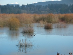
At this point, NC doesn't know if this site is even a possibility as the land is in the ALR -- hence the application to the ALC to find out. It is by no means a done deal. As per OCP policy, a successful application would put another, larger piece of land, (on the 'wet' side of the dike) into the ALR, resulting in no net loss to agriculture. That land is currently farmed, but is not formally protected under the ALR.
I support a public process that will hopefully result in a good decision that builds community instead of dividing us. (no matter where the RCMP is ultimately located)
And I support factual and complete information getting out to the public so we can get informed feedback.
NC staff brought forward a recommendation at its April 17th regular Council meeting.
Watch the presentation and subsequent Council debate here. (It begins at 16:11 minutes and is about 20 minutes long) North Cowichan has also published an information sheet here.
Personally, I have considerable reservations on this site because of my concerns about the impact on a valuable ecological resource. I'm also somewhat concerned that this area is likely to liquify in a large earthquake. There are many questions in my mind.
Ideas about using a very small footprint, building a Platinum Leeds structure and putting the rest of the piece, and the rest of the marsh under a conservation covenant pique my interest. Doing remediation on the marsh, including dealing with invasive species has also been bandied about. I'd like to hear what conservation groups feel about the proposal in light of those kinds of possibilities.
There has been some initial community input at a meeting that around 30 people attended -- most of them not in favor. North Cowichan's Agriculture Committee and Community Planning Committee, both which have community members serving on them, have endorsed the application.
Council voted to take the idea to the next step by sending in the application to ALC. If approved, it would remove that part of the marsh from the ALR while adding the other, larger piece -- presently farmed -- but not zoned into the ALR, thus supporting the OCP's no net loss policy.
Should the ALC approve the application -- NC will probably investigate the feasibility of building on a small corner of the lot. Should the ALC reject the application, NC will have to look at other options. If other viable options were to come to light, they could also be looked at on their own merits.
Proponents point out that one of the attractive aspects of this location is that NC owns the property, which could save $ 1 + million. It's close to the highway. Near the University Village, a concept that envisions a dense mixed use development area -- and in the core, which is a logical good home to the RCMP station.
And so we wait to see what the ALC rules before we can decide next steps.
In the meantime, many people in the community are weighing in and that is as it should be. This is democracy in action folks. Though Council has the ultimate responsibility to make the decision, it is each Councillor's job to weigh all the facts, to listen to all the input from all directions and make the best decision. As I mentioned at the start, we are required to keep an open mind while gathering all that information. I think it's important that citizens have the facts as well and that they get engaged and share their opinions. Opinions formed after they have all the facts. I look at Councillors as public servants, taking their turn to help the community move forward together.
No decision will make everyone happy. There are those who think this is a good idea as well as those who don't. Hopefully, listening to one another, and respectfully communicating with one another, we will come to the best decision.
There has been some inference that NC has already started clearing this land for the RCMP building. That is not correct. The only land that has been cleared is the land in the pathway of the dike. The process for dike construction is to remove all trees where the dike is to go, and then to strip off the topsoil, placing it on either side of the dike alignment so it can be used to finish the dike berms for grass planting. An environmental monitor is ensuring construction of the dike follows Ministry of Environment rules.
The ALC approved the dike construction over ALR land. No additional clearing has been done other than what is required for the dike. A photo has been posted on FB that makes it look like a huge swath of the marsh land aside from the dike was dug up. This is misleading and I have to say, I find it upsetting. The soil in the photo was placed there, to be put back on the edge of the dike once it is constructed. A pre-construction nesting survey was completed by a qualified consultant to ensure there were no nests in the dike alignment. Nesting season is until August and there is an environmental monitor ensuring that construction follows Ministry of Environment rules.
Please inform yourself of all the facts. And if something is confusing to you, never hesitate to ask.
We are all neighbours. Let's work together for the health of us all.

 RSS Feed
